Official Name:
红泉长城5段HongQuanChangCheng5DuanOur Name:
/
Other Name:
/
Period:明
/ Ming Dynasty 1368~1644
Location: 甘肃省,张掖市,甘州区,起点:平山湖蒙古族自治乡红泉村南侧34.1千米止点:平山湖蒙古族自治乡红泉村南侧34.2千米 / GanSuSheng,ZhangYeShi,GanZhouQu,QiDianPingShanHuMengGuZuZiZhiXiangHongQuanCunNanCe341QianMiZhiDianPingShanHuMengGuZuZiZhiXiangHongQuanCunNanCe342QianMi
[
Looking Local List]
Details:长城类别:墙体
起点经纬高度:东经:100° 46′ 北纬:38° 59′ 海拔:2599
终点经纬高度:东经:100° 46′ 北纬:38° 59′ 海拔:2600
墙体走向:总体走向由东北向西南。
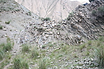
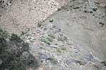
墙体类别及构筑方式:建在沟谷中一座低矮山包和一块独立岩石间,墙体以石块砌筑,墙缝间以细碎砾石、砂土填实作粘合。
墙体类别:石墙
结构特点及构筑方式:无。本段起自第0084点,止于第0085点,全长20米。保存差。整段墙体在南北向山谷内(三道闸子沟),利用东侧一座小山包和西侧一块凸兀的岩石,在两者之间以石块垒砌石墙。东侧山包高6米,西侧独立岩石南北底宽5米、东西长7米。山包与岩石相距10米,其间砌筑一截石墙,底宽2米,顶宽1米,残高0.50米-0.30米,长10米。石墙底部以自然岩石作基,石基底宽5米、残高1.20米、墙体总高1.50米-1.70米,这段墙体上,东端有顶宽3米、底宽2米的“V”形残缺豁口。独立岩石西侧原有石砌墙长3米,现遭人为破坏不存,成为一条山间通道。
现状:
Type:石墙 Stone wall
Protection Level:
Content:
Memo:
Other Records:
Distribution:
visit location in Tianditu Map[recommend] Distribution:
visit location in Tencent QQ Map Distribution:
visit location in Google MapDistribution:
visit location in Baidu MapNational ID:620702382102170008
Action:[
 Save in Data Basket
 ]
Picture:
Click the thumbnail to view the Big Pic. Click the Big Pic to Hide the Big Pic![Caption:红泉长城5段
loading images --Please wait...]()
![Caption:红泉长城5段
loading images --Please wait...]() Photo Links
Photo Links:
 Search ::
  Favorite/My Favorite :: Recent Changes :: :: Login