Official Name:
红泉长城4段HongQuanChangCheng4DuanOur Name:
/
Other Name:
/
Period:明
/ Ming Dynasty 1368~1644
Location: 甘肃省,张掖市,甘州区,起点:平山湖蒙古族自治乡红泉村南侧34.1千米止点:平山湖蒙古族自治乡红泉村南侧33.86千米 / GanSuSheng,ZhangYeShi,GanZhouQu,QiDianPingShanHuMengGuZuZiZhiXiangHongQuanCunNanCe341QianMiZhiDianPingShanHuMengGuZuZiZhiXiangHongQuanCunNanCe3386QianMi
[
Looking Local List]
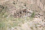
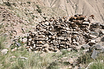
Details:长城类别:墙体
起点经纬高度:东经:100° 46′ 北纬:38° 59′ 海拔:2651
终点经纬高度:东经:100° 46′ 北纬:38° 59′ 海拔:2654
墙体走向:由东向西略偏北。前22米由东向西延伸,末端8米略偏北。
墙体类别及构筑方式:在自然岩石基础上以干石块垒砌,间以细碎砾石砂土填缝粘合,横亘于一条南北走向的峡谷之间。
墙体类别:石墙
结构特点及构筑方式:底宽3.50米,上宽1米,高3米,剖面梯形。
集标本的概括性介绍:无。本段起自第0082点,止于第0083点,全长30米。保存一般。
最高处上下共14层石块,剖面梯形,由底向上渐次收分,间以细碎砾石砂土填缝粘合。底宽3米-3.50米,上宽0.50米-1米,残高1米-3米。石块大小0.08米×15米-0.20米×0.50米。
西侧有宽3米的人为破坏造成的豁口,现成为山间通道。
现状:
Type:石墙 Stone wall
Protection Level:
Content:
Memo:
Other Records:
Distribution:
visit location in Tianditu Map[recommend] Distribution:
visit location in Tencent QQ Map Distribution:
visit location in Google MapDistribution:
visit location in Baidu MapNational ID:620702382102170007
Action:[
 Save in Data Basket
 ]
Picture:
Click the thumbnail to view the Big Pic. Click the Big Pic to Hide the Big Pic![Caption:红泉长城4段
loading images --Please wait...]()
![Caption:红泉长城4段
loading images --Please wait...]() Photo Links
Photo Links:
 Search ::
  Favorite/My Favorite :: Recent Changes :: :: Login