Official Name:
前甘涧长城12段QianGanJianChangCheng12DuanOur Name:
/
Other Name:
/
Period:明 / Ming Dynasty 1368~1644
Location: 天津市,天津市,蓟县,下营镇前甘涧村西南0.5千米 / TianJinShi,TianJinShi,JiXian,XiaYingZhenQianGanJianCunXiNan05QianMi
[
Looking Local List]
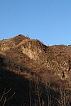
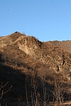
Details:长城类别:墙体
起点经纬高度:东经:117° 24′ 北纬:40° 13′ 海拔:367
终点经纬高度:东经:117° 24′ 北纬:40° 13′ 海拔:404
墙体走向:此段山险自前甘涧小口子公路边为起点,顺山势,至前甘涧长城13段墙体起点处止,走向为东北-西南。
墙体类别:山险
结构特点及构筑方式:利用自然陡峭的山脊,看不出人为加工修整的痕迹。
现状:此段长城为山险。此段山险基本保持原貌,地势陡峭险峻,人类难以攀爬,地理位置尤其重要,山险全长110米。
起点坐标为:东经:117°24′11.70″北纬:40°13′53.46″高程:367米,
止点坐标为:东经:117°24′08.82″北纬:40°13′50.52″高程:404米。
Type:山险 Precipitous mountain areas
Protection Level:省保
Content:
Memo:
Other Records:
Distribution:
visit location in Tianditu Map[recommend] Distribution:
visit location in Tencent QQ Map Distribution:
visit location in Google MapDistribution:
visit location in Baidu MapNational ID:120225382106170168
Action:[
 Save in Data Basket
 ]
Picture:
Click the thumbnail to view the Big Pic. Click the Big Pic to Hide the Big Pic![Caption:前甘涧长城12段
loading images --Please wait...]()
![Caption:前甘涧长城12段
loading images --Please wait...]() Photo Links
Photo Links:
 Search ::
  Favorite/My Favorite :: Recent Changes :: :: Login