Official Name:
前甘涧长城2段QianGanJianChangCheng2DuanOur Name:
/
Other Name:
/
Period:明 / Ming Dynasty 1368~1644
Location: 天津市,天津市,蓟县,下营镇前甘涧村东北1.25千米 / TianJinShi,TianJinShi,JiXian,XiaYingZhenQianGanJianCunDongBei125QianMi
[
Looking Local List]
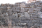
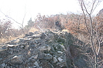
Details:长城类别:墙体
起点经纬高度:东经:117° 25′ 北纬:40° 14′ 海拔:681
终点经纬高度:东经:117° 25′ 北纬:40° 14′ 海拔:700
墙体走向:此段墙体自前甘涧长城1段山险止点,顺山势,至前甘涧长城3段山险墙起点,走向为东北至西南走向。
墙体类别:石墙
结构特点及构筑方式:该段长城采用石块干垒而成。
垒砌方法:
从部分墙体断面观察,墙体的垒砌方法与以往的墙体基本相同,也是墙体的内外两侧均采用较大的石块垒砌成两道外墙边,然后在这两道墙体中间用相对小的石块和碎石片、土填充,形成完整的墙体。墙体有收分。
现状:此段长城为石墙。此段长城墙体保存一般,全长89米,按特征点可分为2小段来描述:
1、起点坐标:117°25′40.02″E,40°14′29.40″N,海拔681米,止点坐标:117°25′40.68″E,40°14′27.78″N,海拔689米。
此小段墙体长58米,保存一般,外墙高1.90米,内墙高0.70米,墙宽1.90米。止点向西南上折。
2、起点坐标:117°25′40.68″E,40°14′27.78″N,海拔689米,止点坐标:117°25′37.74″E,40°14′27.24″N,海拔700米。
此小段墙体长31米,保存一般,内、外墙部分倒塌,外墙高1.70米,内墙高1.50米,墙宽1.90米。
Type:石墙 Stone wall
Protection Level:省保
Content:
Memo:
Other Records:
Distribution:
visit location in Tianditu Map[recommend] Distribution:
visit location in Tencent QQ Map Distribution:
visit location in Google MapDistribution:
visit location in Baidu MapNational ID:120225382102170158
Action:[
 Save in Data Basket
 ]
Picture:
Click the thumbnail to view the Big Pic. Click the Big Pic to Hide the Big Pic![Caption:前甘涧长城2段
loading images --Please wait...]()
![Caption:前甘涧长城2段
loading images --Please wait...]() Photo Links
Photo Links:
 Search ::
  Favorite/My Favorite :: Recent Changes :: :: Login