Official Name:
青山岭长城2段QingShanLingChangCheng2DuanOur Name:
/
Other Name:
/
Period:明 / Ming Dynasty 1368~1644
Location: 天津市,天津市,蓟县,下营镇青山岭长城1号敌台北侧 / TianJinShi,TianJinShi,JiXian,XiaYingZhenQingShanLingChangCheng1HaoDiTaiBeiCe
[
Looking Local List]
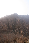
Details:长城类别:墙体
起点经纬高度:东经:117° 29′ 北纬:40° 12′ 海拔:486
终点经纬高度:东经:117° 29′ 北纬:40° 12′ 海拔:524
墙体走向:此段山险自青山岭1号敌台向北,顺山势,至青山岭长城2号敌台止,走向为南至北走向。
墙体类别:山险
结构特点及构筑方式:利用自然陡峭的山脊,看不出人为加工修整的痕迹。
现状:此段长城为山险,基本保持原貌。此段山险基本保持原貌,全长150米。在山险起点处向北20m处,有已个山谷,山谷为东西向,穿过这段山险宽约30米,在2号敌台南20m处有一个人为修建的观景台,平面为正方形,边长10m。在山险的顶部有一小道纵向穿过这段山险,山险顶部较为平坦,上面长满杂草,山险东西两侧均为悬崖峭壁,南北为陡坡。山险上植被为杂草、树木。
起点坐标:东经:117°29′57.06″北纬:40°12′17.76″高程:486米,
止点坐标:东经:117°29′57.24″北纬:40°12′22.56″高程:524米。
Type:山险 Precipitous mountain areas
Protection Level:省保
Content:
Memo:
Other Records:
Distribution:
visit location in Tianditu Map[recommend] Distribution:
visit location in Tencent QQ Map Distribution:
visit location in Google MapDistribution:
visit location in Baidu MapNational ID:120225382106170089
Action:[
 Save in Data Basket
 ]
Picture:
Click the thumbnail to view the Big Pic. Click the Big Pic to Hide the Big Pic![Caption:青山岭长城2段
loading images --Please wait...]() Photo Links
Photo Links:
 Search ::
  Favorite/My Favorite :: Recent Changes :: :: Login