Official Name:
��̨������BaiTaiGouChangChengOur Name:
/
Other Name:
/
Period:�� / Ming Dynasty 1368~1644
Location: ������,��Ʊ��,��㣺����Ӫ����ү�����̨����(����1350��ɽ��)ֹ�㣺����Ӫ����ү�����̨����(����1200��ɽ��) / ChaoYangShi,BeiPiaoShi,QiDianChangHeYingXiangLaoYeMiaoCunBaiTaiGouTun(XiBei1350MiGaoShanShang)ZhiDianChangHeYingXiangLaoYeMiaoCunBaiTaiGouTun(XiNan1200MiGaoShanShang)
��[
Looking Local List]
Details:�������ǽ��
��㾭γ�߶ȣ�������121�� 13�� ��γ��41�� 43�� ���Σ�683
�յ㾭γ�߶ȣ�������121�� 12�� ��γ��41�� 42�� ���Σ�534
ǽ������ǽ�����ʶ���-����ת��ת�������öγ������Գ
ǽ�����ɽ��
�ṹ�ص㼰������ʽ�����治�����Ρ��ö�ɽ�����������վ���ɽ���ͱڣ���ɽ���������Ȼ�γɵ�һ����Ȼ���ϣ�ǽ����ʩ�档
��״��ɽ�ա�
Type:ɽ�� Precipitous mountain areas
Protection Level:��
��
Content:
Memo:
Other Records:
Distribution:
visit location in Tianditu Map[recommend] Distribution:
visit location in Tencent QQ Map Distribution:
visit location in Google MapDistribution:
visit location in Baidu MapNational ID:211381382106170001
Action:[
 Save in Data Basket
 ]
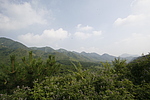
Picture:
Click the thumbnail to view the Big Pic. Click the Big Pic to Hide the Big Pic![Caption:��̨������
loading images --Please wait...]() Photo Links
Photo Links:
�� Search ::
  Favorite/My Favorite :: Recent Changes :: :: Login