Official Name:
兴民村5段土墙XingMinCun5DuanTuQiangOur Name:
北长城 / BeiChangCheng
Other Name:
/
Period:明 / Ming Dynasty 1368~1644
Location: 宁夏回族自治区,石嘴山市,大武口区,长兴办事处兴民村西约2.4千米的枣儿沟山脚下――长兴办事处兴民村西约2.5千米的枣儿沟半坡处 / NingXiaHuiZuZiZhiQu,ShiZuiShanShi,DaWuKouQu,ChangXingBanShiChuXingMinCunXiYue24QianMiDeZaoErGouShanJiaoXiaChangXingBanShiChuXingMinCunXiYue25QianMiDeZaoErGouBanPoChu
[
Looking Local List]
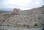
Details:长城类别:墙体
起点经纬高度:东经:106° 23′ 北纬:39° 2′ 海拔:1125
终点经纬高度:东经:106° 23′ 北纬:39° 3′ 海拔:1156
墙体走向:此段土墙,自枣儿沟山脚下土墙的起点处(GPS0113点)开始,沿山坡辗转而上,最后到半山坡陡崖处(GPS0119点)截止,全长118.5米。墙体随山体分布,地势北高南低,落差较大;方向不甚直,大致呈东南--西北向。
墙体类别:土墙
结构特点及构筑方式:此段墙体是在山体的砾石地表上找平、用夹杂少量青灰色小石块的黄沙土夯筑而成,土质粘细,色沙黄,含水量少。
现状:土墙。
Type:土墙 Rammed earth wall
Protection Level:省保
Content:
Memo:
Other Records:
Distribution:
visit location in Tianditu Map[recommend] Distribution:
visit location in Tencent QQ Map Distribution:
visit location in Google MapDistribution:
visit location in Baidu MapNational ID:640202382101170010
Action:[
 Save in Data Basket
 ]
Picture:
Click the thumbnail to view the Big Pic. Click the Big Pic to Hide the Big Pic![Caption:兴民村5段土墙
loading images --Please wait...]() Photo Links
Photo Links:
 Search ::
  Favorite/My Favorite :: Recent Changes :: :: Login