Official Name:
永兴村1段山险YongXingCun1DuanShanXianOur Name:
城西南墙 / ChengXiNanQiang
Other Name:
/
Period:明 / Ming Dynasty 1368~1644
Location: 宁夏回族自治区,中卫市,中宁县,余丁乡余丁村北约1.8千米--余丁乡永兴村北约1.6千米 / NingXiaHuiZuZiZhiQu,ZhongWeiShi,ZhongNingXian,YuDingXiangYuDingCunBeiYue18QianMiYuDingXiangYongXingCunBeiYue16QianMi
[
Looking Local List]
Details:长城类别:墙体
起点经纬高度:东经:105° 33′ 北纬:37° 30′ 海拔:1214
终点经纬高度:东经:105° 30′ 北纬:37° 30′ 海拔:1272
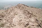
墙体走向:此段山险,自余丁乡余丁村以北的土墙截止点(GPSA0400点)起,随山体辗转向西,最后延伸至永兴十队石墙的起点处(GPSA0414点),直线距离为3120米。此段山险直接利用该处陡峭的山体,不砌墙体。地势上随山体有高低起伏,落差较大;方向较曲折,大致呈东-西向。
墙体类别:山险
结构特点及构筑方式:无。
采集标本概括性介绍:
无。此段山险直接利用陡峭山体及自然冲沟构成天然防线,不砌墙体。
现状:属自然山险。
Type:山险 Precipitous mountain areas
Protection Level:省保
Content:
Memo:
Other Records:
Distribution:
visit location in Tianditu Map[recommend] Distribution:
visit location in Tencent QQ Map Distribution:
visit location in Google MapDistribution:
visit location in Baidu MapNational ID:640521382106170171
Action:[
 Save in Data Basket
 ]
Picture:
Click the thumbnail to view the Big Pic. Click the Big Pic to Hide the Big Pic![Caption:永兴村1段山险
loading images --Please wait...]() Photo Links
Photo Links:
 Search ::
  Favorite/My Favorite :: Recent Changes :: :: Login