Official Name:
金沙村2段山险墙JinShaCun2DuanShanXianQiangOur Name:
城西南墙 / ChengXiNanQiang
Other Name:
/
Period:明 / Ming Dynasty 1368~1644
Location: 宁夏回族自治区,中卫市,中宁县,余丁乡金沙村以北约5.2千米--余丁乡金沙村以北约5.2千米 / NingXiaHuiZuZiZhiQu,ZhongWeiShi,ZhongNingXian,YuDingXiangJinShaCunYiBeiYue52QianMiYuDingXiangJinShaCunYiBeiYue52QianMi
[
Looking Local List]
Details:长城类别:墙体
起点经纬高度:东经:105° 34′ 北纬:37° 35′ 海拔:1308
终点经纬高度:东经:105° 34′ 北纬:37° 35′ 海拔:1307
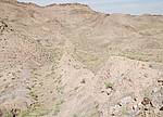
墙体走向:此段山险墙,自山嘴半坡处(GPSA0303点)开始,沿此道大致成东西向的山嘴南坡向东,一直到东侧山梁间的小山凹处(GPSA0304点)截止,全长82.1米。此段基本属直接利用陡峭山体、凿山为险,地势上由西向东略有下降,但降幅不大;方向较直,呈西北-东南向。
墙体类别:山险墙
结构特点及构筑方式:无。
采集标本概括性介绍:
无。此段山险墙是直接利用较陡峭的山体为险,将山体表面砍削成陡崖,底部形成一道平台;在个别山脊略低矮处再在顶部砌石加高。
现状:山险墙。
Type:山险墙 Precipitous mountain areas as wall
Protection Level:省保
Content:
Memo:
Other Records:
Distribution:
visit location in Tianditu Map[recommend] Distribution:
visit location in Tencent QQ Map Distribution:
visit location in Google MapDistribution:
visit location in Baidu MapNational ID:640521382105170157
Action:[
 Save in Data Basket
 ]
Picture:
Click the thumbnail to view the Big Pic. Click the Big Pic to Hide the Big Pic![Caption:金沙村2段山险墙
loading images --Please wait...]() Photo Links
Photo Links:
 Search ::
  Favorite/My Favorite :: Recent Changes :: :: Login