Official Name:
甘盐池堡GanYanChiBaoOur Name:
甘盐池城 / GanYanChiCheng
Other Name:
/
Period:明 / Ming Dynasty 1368~1644
Location: 宁夏回族自治区,中卫市,海原县,甘盐池羊场邵家庄村西1千米 / NingXiaHuiZuZiZhiQu,ZhongWeiShi,HaiYuanXian,GanYanChiYangChangShaoJiaZhuangCunXi1QianMi
[
Looking Local List]
Details:长城类别:关堡
经纬高度:东经:105° 15′ 北纬:36° 39′ 海拔:1991
总体情况:
附近遗存:无。
地质地形地貌:
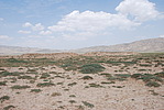
该地区属于陇中山地与黄土丘陵区。具有山间洼地的黄土丘陵与侵蚀中山、低中山交错分布,山地突起被黄土丘陵包围;丘陵中沟壑发育,地形子离破碎;整体地势由西南向东北倾斜。
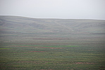
堡周围整体地形平坦,为一平川。关堡南与长城土墙之间有水冲刷形成浅沟。关堡内长满杂草。西距塘坡敌台1890米,东北距邵家庄烽火台2300米。
Type:堡 Fort
Protection Level:省保
Content:
Memo:
Other Records:
Distribution:
visit location in Tianditu Map[recommend] Distribution:
visit location in Tencent QQ Map Distribution:
visit location in Google MapDistribution:
visit location in Baidu MapNational ID:640522353102170002
Action:[
 Save in Data Basket
 ]
Picture:
Click the thumbnail to view the Big Pic. Click the Big Pic to Hide the Big Pic![Caption:甘盐池堡
loading images --Please wait...]()
![Caption:甘盐池堡
loading images --Please wait...]() Photo Links
Photo Links:
 Search ::
  Favorite/My Favorite :: Recent Changes :: :: Login