Official Name:
东岔东长城DongChaDongChangChengOur Name:
/
Other Name:
/
Period:汉
/ Han Dynasty 206 B.C.~316A.D.
Location: 甘肃省,酒泉市,金塔县,起点:航天镇东岔村南3.12千米处止点:航天镇东岔村东5.19千米处 / GanSuSheng,JiuQuanShi,JinTaXian,QiDianHangTianZhenDongChaCunNan312QianMiChuZhiDianHangTianZhenDongChaCunDong519QianMiChu
[
Looking Local List]
Details:长城类别:墙体
起点经纬高度:东经:099° 44′ 北纬:40° 23′ 海拔:1149
终点经纬高度:东经:099° 46′ 北纬:40° 24′ 海拔:1142
墙体走向:
墙体类别:土墙
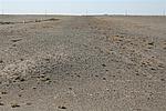
结构特点及构筑方式:无。该墙体为自然基础,土质疏松,墙体剖面呈圆丘状,底宽9.30米-12米,残高0.60米-1.20米不等。
该段墙体起自第1073点,止于第1079点,全长3238米,根据保存现状和结构特点,分为五个自然段。
第一自然段:起自第1073点,止于第1074点,长1878米。该段墙体保存较差,因常年风吹雨淋,酥碱坍塌成土垄状。墙体两侧风蚀坍塌成斜坡面,底宽9.30米,残高0.60米。
第二自然段:起自第1074点,止于第1075点,长44米。该段墙体保存差,因洪水冲刷,地面只残留痕迹,形成豁口。
第三自然段:起自第1075点,止于第1076点,长396米。该段墙体保存较差,因常年风吹雨淋,酥碱坍塌成土垄状。墙体两侧风蚀坍塌成斜坡面,底宽12米,残高1.20米。
第四自然段:起自第1076点,止于第1078点,长420米。该段墙体已消失。
第五自然段:起自第1078点,止于第1079点,长500米。该段墙体保存较差,因常年风吹雨淋,酥碱坍塌成土垄状。墙体两侧风蚀坍塌成斜坡面,底宽12米,残高1.20米。
现状:
Type:土墙 Rammed earth wall
Protection Level:
Content:
Memo:
Other Records:
Distribution:
visit location in Tianditu Map[recommend] Distribution:
visit location in Tencent QQ Map Distribution:
visit location in Google MapDistribution:
visit location in Baidu MapNational ID:620921382101040078
Action:[
 Save in Data Basket
 ]
Picture:
Click the thumbnail to view the Big Pic. Click the Big Pic to Hide the Big Pic![Caption:东岔东长城
loading images --Please wait...]() Photo Links
Photo Links:
 Search ::
  Favorite/My Favorite :: Recent Changes :: :: Login